Free shipping over $99 & on maps
Green Trails Australia Green Trails Australia

SEARCH

0
  • Hiking Trail Info
    • Hiking Trail Guides
    • Hiking Trail Difficulty
    • Parks Victoria Digital Maps
  • Shop
    • Brands
    • Orders & Shipping
    • Returns & Warranties
  • My account
    • Login or Register
    • Edit Account
    • Cart
    • Checkout
  • Meetup Events
    • Green Trails Day Hikes
      • Green Trails Day Hikes 2022
      • Green Trails Day Hikes 2021
      • Green Trails Day Hikes 2020
      • Green Trails Day Hikes 2019
      • Green Trails Day Hikes 2018
      • Green Trails Day Hikes 2017
    • Green Trails Pack Carry Hikes
      • Green Trails Pack Carry Hikes 2023
      • Green Trails Pack Carry Hikes 2022
      • Green Trails Pack Carry Hikes 2021
      • Green Trails Pack Carry Hikes 2020
      • Green Trails Pack Carry Hikes 2019
      • Green Trails Pack Carry Hikes 2018
    • Becoming a Hike Leader
    • Waiver of Liability and Risk
  • Contact
October 26, 2017August 28, 2026
0

The Canyon and Phantom Falls

by greentain Great Ocean Roadtags 1–3 hours, 250–500m ascent, 5–10km, Grade 3, Loop, Otway Forest Park, Otways
The Canyon And Phantom Falls

The Canyon and Phantom Falls passes several waterfalls including Won Wondah Falls, Henderson Falls, and Phantom Falls, and we will also be walking through The Canyon. This hike is suitable for most people.

Lorne is a beautiful area and offers some stunning hikes within the Otway Forest Park. Countless waterfalls and river crossings, forest ferns – what more could you want? Views? Yes there are some views on offer too, but in all honesty when you have waterfalls, who needs views?

This is a Grade 3 walk. Total distance of the track is 9.5km. Suitable for most ages and fitness levels. Formed earthen track, few obstacles. Kept mostly clear of intrusions and obstacles.

Trail Head Options:

  • Drive to Allenvale Mill Car Park down Allenvale Road from Lorne.

The Canyon and Phantom Falls hiking trail is 9.5km long and will take about 3 hour to complete.

Trail Features:

  • Waterfalls
  • Canyon

It is always nice to complete any hiking trails in the region after recent rainfalls maximising water flow at the waterfalls. This can result in muddy trails, but it is well worth it.

Trail End Options:

  • Upper and Lower Kalimna Falls, a 2km drive away.
  • Sheoak Falls Walk, a 7km drive away.
  • Erskine Falls Walk, an 11km drive away.

Trail Statistics:

  • Starting Point: Allenvale Mill Car Park
  • Hiking Trail Difficulty: Grade 3
  • Distance: 9.5km
  • Trail Type: Loop Hike
  • Elevation Gain: 350m
  • Elevation Loss: 350m
  • Minimum Elevation: 40m
  • Maximum Elevation: 210m
  • Time to Complete: Up to 3 hours
  • Ending Point: Allenvale Mill Car Park
© OpenStreetMap contributors

Detailed Hiking Trail Guide:

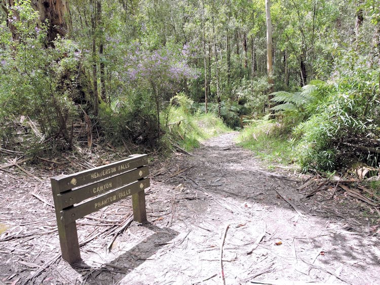
The start of this hike is from Allenvale Mill Car Park, as pictured. There is also a campground a short walk down the path which is free – you may choose to camp here should you so wish. The campground is clean and has toilets.
The first section of this hike is along the road that you drove in on. Turn left onto the road.
Continue over the bridge and up the road which is uphill for about 1.5km.
The road is called Garvey Track from here.
When you reach this fork in the road, keep to the RIGHT.
You’ll see a gate which is seasonally closed. Continue up this road for a short way.
You’ll see a trail that comes in from the left. Look for the connecting trail on the right hand side of the road.
Turn RIGHT here towards Henderson Falls and Won Wondah Falls.

At this fork in the trail, you will find Won Wondah Falls down to the RIGHT. We will come back up this way to head towards Henderson Falls next.
Won Wondah Falls viewing platform.
Won Wondah Falls can be seen below, all be it somewhat obscured by fallen trees.
Heading back up the trail to the fork, turn RIGHT towards Henderson Falls.

We are going STRAIGHT here to get to Henderson Falls. We’ll be back later.
These hiking trails can become somewhat muddy after recent rainfalls.

Henderson Falls.
Head back up the hiking trail towards the fork we passed earlier.

Turn LEFT here towards The Canyon.

As the come under some rocks and up this passage turn left towards Phantom Falls.

Turn RIGHT here towards Phantom Falls.
Keep along the main track as we pass some private properties.

Take a LEFT at the bottom heading towards Phantom Falls.

What you see ahead is the top of Phantom Falls. Turn RIGHT to get to the bottom.

After checking out Phantom Falls, you will come back up this track.

The Canyon And Phantom Falls
It’s quite nice down here, a good place to sit and rest, have a snack or lunch, and have a look around.
Head back up the hill to the top of Phantom Falls.
Take a left at the top.
And continue straight ahead…
…towards Allenvale.
Very steep downhill bit here. Take care or get your hiking poles out!
Continue straight ahead along the narrower path.

Continue straight.
The trail continues between two properties here with horses on one side, cows on the other, and a orchard at the end.
Continue straight ahead and around to the back of the orchard,

At the road, turn LEFT.
And you’ll find yourself back at Allenvale Mill Car Park. Check out Trail End Options above for additional hiking trails around the area.

Like this post?

Facebook Twitter Pinterest
Previous Post LinkUpper and Lower Kalimna FallsNext Post LinkErskine Falls Walk

More posts

Great South West Walk
January 9, 2018
Great South West Walk
Falcons Lookout
September 19, 2017
Falcons Lookout

Hiking Trail Guides

  • Blog (4)
  • Hiking Trails (70)
    • Victoria (70)
      • Daylesford and the Macedon Ranges (4)
      • Geelong and the Bellarine (1)
      • Gippsland (4)
      • Grampians (6)
      • Great Ocean Road (23)
      • Melbourne (2)
      • Mornington Peninsula (2)
      • Victoria’s High Country (5)
      • Yarra Valley and Dandenong Ranges (23)
  • Product Reviews (2)

Hiking Gear for Sale

  • Accessories (100)
    • Battery Packs (3)
    • Compasses (4)
    • Emergency (6)
    • Hiking Poles (22)
    • Lighting (35)
    • Miscellaneous (27)
    • Pack Covers (2)
    • Seats (1)
    • Tent Pegs (1)
    • Towels (2)
  • Books (104)
    • Camping (12)
    • Fauna (10)
    • Four Wheel Drive (29)
    • Hiking Trails (31)
    • Outback (3)
    • Touring (16)
    • Travel Guide (16)
  • Clothing (17)
    • Gaiters (9)
    • Ponchos (3)
    • Rainwear (1)
    • Thermal (4)
  • Hiking Maps (326)
    • TasMap 50K Scale (57)
    • Queensland (1)
    • ACT (2)
    • Map Packs (5)
    • New South Wales (22)
    • South Australia (18)
    • Tasmania (15)
    • Victoria (84)
    • Vicmap 25K Scale (48)
    • Vicmap 50K Scale (88)
    • Western Australia (-1)
  • Kitchen (60)
    • Bowls Plates & Cups (8)
    • Cooking (48)
    • Cutlery (4)
  • Maps & Guides (290)
    • Vicmap 100K Scale (70)
    • Wall Maps (16)
    • Four Wheel Drive (72)
    • Information Maps (1)
    • Map Guides (36)
    • Map Packs (4)
    • New Zealand (5)
    • Touring Map (93)
    • Tourist Maps (21)
  • Sleeping (50)
    • Accessories (3)
    • Bags (14)
    • Hammocks (1)
    • Liners (4)
    • Mats (21)
    • Pillows (8)
  • Storage (59)
    • Compression Sacks (4)
    • Day Packs (4)
    • Dry Sacks (12)
    • Miscellaneous (3)
    • Water Bladders (35)
    • Waterproof Cases (1)

Cart

Fire Danger Info

  • MyFireWatch Australia Bushfire Map
  • ACT Emercency Services Agency
  • NSW Rural Fire Service
  • NT Bushfire Alerts & Warnings
  • Queensland Current Bushfires
  • SA CFS Warnings & Incidents
  • Tasmania Fire Service Map
  • VIC Emergency Incidents & Warnings
  • Emergency WA Warnings & Incidents
  • Waiver
  • Orders & Shipping
  • Returns & Warranties
  • Privacy
  • T & C
Privacy / © 2025 Green Trails Australia - ABN 99 549 421 353